this thread is for those of you who are interested in making maps for the lands of classic castle group project. for right now your map should be a rough draft that shows only major land marks, more details can be added later. the dead line is this Saturday, I know its not much time but a draft shouldn't take very long
EDIT: the submission time for map contest is over
you can vote for you favorite map here
Also keep in mind that the map chosen will have to be tweaked later to completely fit with all the other details. The map should be finalized made after the lore.
just to make thing a bit more organized I am putting a link to all entries in the first post.
Just to clarify, I think that once a draft is chosen, the next stage of the process - creating a proper map - will open to everyone, not just the one who made the chosen draft.
The factions to keep in mind when designing the map are:
"Red" - Grasslands
"Green" - Forests
"Blue" - Mountains / Snow
"Gold" - Swamps / Dark Forest
"Rebels" - No real official territory, other than a mystic island.
wobnam wrote:Just to clarify, I think that once a draft is chosen, the next stage of the process - creating a proper map - will open to everyone, not just the one who made the chosen draft.
Yes exactly so.
Sir Mencot Paladin and rogue
[img]http://www.brickshelf.com/gallery/lord-of-orks/map/rankings/citizen3.jpg[/img][img]http://farm9.staticflickr.com/8244/8487960182_6a051704d4_t.jpg[/img][img]http://farm9.staticflickr.com/8120/8636932919_7220cc2cc9_m.jpg[/img]
[url=http://www.flickr.com/photos/mencot]Flickr[/url]
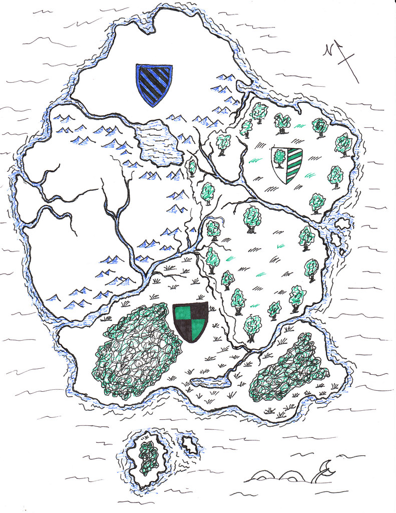
I made a draft of a map not final, I put some names there also. I know that they are a bit corny and probably wrong spelled. But I thought it sounded good in french http://www.flickr.com/photos/mencot/set ... 220578333/
Sir Mencot Paladin and rogue
[img]http://www.brickshelf.com/gallery/lord-of-orks/map/rankings/citizen3.jpg[/img][img]http://farm9.staticflickr.com/8244/8487960182_6a051704d4_t.jpg[/img][img]http://farm9.staticflickr.com/8120/8636932919_7220cc2cc9_m.jpg[/img]
[url=http://www.flickr.com/photos/mencot]Flickr[/url]
I thought I'd give it a shot as well. No borders drawn yet - except the natural ones, nor all the land occupied.
The very centers of the factions are depicted, but not named.
I know this might not be the right place, but I just throw in an idea: It would be awesome with an interactive map, where you can mouse over a pixel and then see the buildings at that location.
Bentoft wrote:I know this might not be the right place, but I just throw in an idea: It would be awesome with an interactive map, where you can mouse over a pixel and then see the buildings at that location.
I suggested that on the other thread but it seems liek it may be hard to do. Still I think it is possible too!
With FlickR, I believe this could be done to some extent. When the final map is chosen, the maker could add non-overlapping notes (little "signs" on the picture, in case you'e not familiar with FlickR) with links to the builds located there. Furthermore, we could have a full map of the whole LCC world, with notes leading to maps of the separate factions' lands. Werefrom there could then be notes leading to the actual builds. This way, the map will get less cluttered and messy, and you will actually be able to have two buildings in the same town.
richardanthonyc wrote:I suggested that on the other thread but it seems liek it may be hard to do. Still I think it is possible too!
Any html nerd could do that. The hard thing is the make a page where maybe all region leaders could add pictures in a user friendly way. Else the html nerd would have a lot of work
Bentoft wrote:I know this might not be the right place, but I just throw in an idea: It would be awesome with an interactive map, where you can mouse over a pixel and then see the buildings at that location.
I suggested that on the other thread but it seems liek it may be hard to do. Still I think it is possible too!
With FlickR, I believe this could be done to some extent. When the final map is chosen, the maker could add non-overlapping notes (little "signs" on the picture, in case you'e not familiar with FlickR) with links to the builds located there. Furthermore, we could have a full map of the whole LCC world, with notes leading to maps of the separate factions' lands. Werefrom there could then be notes leading to the actual builds. This way, the map will get less cluttered and messy, and you will actually be able to have two buildings in the same town.
Yes this would be good and cool
Sir Mencot Paladin and rogue
[img]http://www.brickshelf.com/gallery/lord-of-orks/map/rankings/citizen3.jpg[/img][img]http://farm9.staticflickr.com/8244/8487960182_6a051704d4_t.jpg[/img][img]http://farm9.staticflickr.com/8120/8636932919_7220cc2cc9_m.jpg[/img]
[url=http://www.flickr.com/photos/mencot]Flickr[/url]
Bentoft wrote:I know this might not be the right place, but I just throw in an idea: It would be awesome with an interactive map, where you can mouse over a pixel and then see the buildings at that location.
I suggested that on the other thread but it seems liek it may be hard to do. Still I think it is possible too!
With FlickR, I believe this could be done to some extent. When the final map is chosen, the maker could add non-overlapping notes (little "signs" on the picture, in case you'e not familiar with FlickR) with links to the builds located there. Furthermore, we could have a full map of the whole LCC world, with notes leading to maps of the separate factions' lands. Werefrom there could then be notes leading to the actual builds. This way, the map will get less cluttered and messy, and you will actually be able to have two buildings in the same town.


