Peppermint Pig wrote:no infrastructure for altitude mapping (not that I would expect it, since it's meant to be a basic tiling system)
Quite possible actually. Observe this shot:
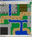
The white markers in the upper left corner denote the cliffs should be 7 bricks high (height of a LURP) and any baseplates behind the arrows should be raised accordingly (
like so). You'll be able to place the markers anywhere and denote any height.
I can see the benefits of this program for getting the first schematic together, but based on unique designs of contributors, we'd probably end up going back to ldraw and photographs (shooting cross-sections of castle walls, where minutiae matters, for example) for individual piece precision.
Ah, but this is not the point of a modular system! Perhaps it is confusing with everything being in a grid. The only thing that matters here are the
edges. Allow me to explain by example.
Say someone is contributing a 32x32 baseplate and two 32x16's worth of terrain to a display. The display coordinator figures in their overall scheme that the area should have a road that runs from one side to the other with a CCC gatehouse on one side and some cliffs in the corner, like so:
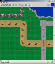
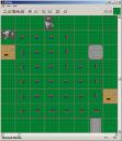
All the contributor needs to know is where on the edges of his baseplates the road, wall, and cliffs connect. All the coordinator need send them is this:
The contributor can fill in everything inbetween however they see fit, as long as they match the edges. They do not have to adhere to 8x8 modules within their own borders, and the coordinator does not have to worry about any details because they know whatever the contributor makes will match whatever terrain is assigned to the other contributors around it. Everyone just has to keep to a defined set of "edge" standards, aka roads should be tan and 8 studs wide when they meet, CCC walls are 4 studs wide and 8 1/3 bricks tall, cliffs are 4 studs wide and 7 bricks tall, etc. Trying to coordinate a display just based off each contributors unique designs would be insanely complicated, a modular standard is meant to remove that complication.
I think it might be better, in some cases, to just map out the highways (ensure people build a common way and not a winding path resulting from random moc placement), grass, forests, and waterways, then give people lots where they can add buildings, secondary roadways, and other natural details.
Exactly.

As long as the edges match, people can build whatever they want.


